Light My Fire

My pictures don’t do justice to the beauty of the hoar frost that covered the trees this morning when I arrived at the Springs.  It was cold and my fingers were freezing as I took these pics.

IMG_0305 IMG_0308

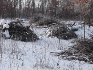
This was taken from the Marl Pit bridge and shows the hillside above the Indian Springs where we planned to burn.

IMG_0312 IMG_0313 IMG_0314 IMG_0315

Here is a closer look at the piles we planned to light up.

IMG_0318 IMG_0322 IMG_0323 IMG_0324

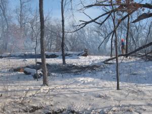
The conditions were perfect.  A light but steady wind out of West and clear skies.  Lindsay and Pati came out to help and enjoy the beautiful day.

IMG_0325

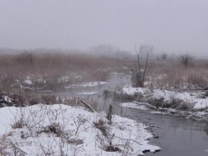
Below you can see where the two forks of the Indian Springs outflow merge on their way to the Scuppernong River.

IMG_0326 IMG_0327 IMG_0328

Lindsay used a leave blower to help jump start the fires when they needed a blast of air and it worked pretty darn good.

IMG_0331 IMG_0332 IMG_0333

The view from the Marl Pit bridge. You can see where the channel from the Indian Springs joins the river.

IMG_0337

We burned 22 piles today and I think we have 3-4 more day’s work to finish the piles in this area.  I had to leave early so Pati and Lindsay handled the mop up operations. Thanks!

See you at the Springs!

Let Me Stand Next To Your Fire

I took advantage of the East wind yesterday to burn 15 brush piles right along Hwy 67.  This is the area where the barn once stood that was part of the Parker Hotel and Mann/Dousman/Parker Trout Ponds complex.  THE PONDS OF THE SCUPPERNONG is a fascinating history that has deepened my appreciation for the opportunity I have to spend so much time at this wonderful place that was cherished by so many people over the years.

My plan was to burn the phragmites piles along the river first.

IMG_0271

That proved impossible as they were thoroughly soddened.  I quickly gave that up and went over to the old barn site.

IMG_0272 IMG_0274 IMG_0276

I’ve been concerned about burning these piles, given their close proximity to Hwy 67, and the light, Easterly winds provided the perfect conditions.

IMG_0280 IMG_0282 IMG_0283 IMG_0285 IMG_0286

Here is the old barn foundation.

IMG_0288 IMG_0291

The view from Hwy 67 is beautiful, albeit, a bit loud.  I filmed from the edge of the road and then wandered down to the edge of the barn foundation shown above.  You can see 15 or so brush piles between the trail and the River that we hope to burn tomorrow.

See you at the Springs!

THE PONDS OF THE SCUPPERNONG

The Upper Pond, Photo by Pete Nielsen

The Upper Pond, Photo by Pete Nielsen

I didn’t know what Robert Duerwachter was referring to in his book title.  What ponds?  I never saw, or at least I don’t remember seeing, the two trout ponds that made the Scuppernong Springs famous.  If you love The Springs, you must pick up your very own copy of “THE PONDS OF THE SCUPPERNONG” at Forest Headquarters.  I can’t summarize it any better than the author:

A NARRATIVE OF PEOPLE, ACHIEVEMENTS AND

LITTLE KNOWN FACTS IN THE LIVES AND TIMES

OF THOSE WHO MADE SIGNIFICANT CONTRIBUTIONS

TO THE PONDS IN THE SOUTHEAST QUARTER OF

SECTION 34 IN THE TOWN OF OTTAWA

WAUKESHA COUNTY, WISCONSIN

CHESTER M. SMITH

THE DOUSMAN FAMILY

CURTIS AND NANCY MANN

ELIPHALET S. STONE

THE PARKER FAMILY

THE PERELES FAMILY

ORIN C. BENSON

I love history and this, picture filled, page turner is the definitive history of the Scuppernong Springs.

Finally, we can start burning some brush piles.  I think there might be over 300.  First, a few morning views of the Scuppernong River:

IMG_0229 IMG_0232 IMG_0234

Our goal was to burn all of the piles on the “inside” of the big bend in the river by the Old Hotel Site.

IMG_0230 IMG_0231

Rich Csavoy arrived early and we got after it.

IMG_0238 IMG_0239

Pati, a veteran brush pile burner, joined in the fun.

IMG_0242 IMG_0246 IMG_0245

I got these pics while mopping up.

IMG_0253 IMG_0254 IMG_0255 IMG_0261 IMG_0263

After the gear was all stowed away, I took a walk along the river and saw the biggest flock of geese I have ever seen in my life.  It must have stretched out over a mile…

IMG_0264 IMG_0267

You gotta hear them…

It was a blessed day at the Springs and we burned 19 piles.

Happy Holidays and I Hope to see you out at the Springs!

Break On Through To The Other Side

Morning view of the Springs.

IMG_0223

IMG_0224

I can’t believe we got the Lost Trail opened up before the big snow came!  Lindsay really got after it last Sunday and showed me what was possible.  With that inspiration, I finished opening up the cut-off trail today.  Here are a few before pics.

IMG_0226 IMG_0227

And After…

IMG_1034 IMG_1036

This temporary bridge will be replaced with something nicer next year.  You can see a bit of the Marl factory.

IMG_1037

Speaking of “Marl”, a man who really inspires me is Marlin Johnson, retired Biology Teacher at the University of Wisconsin, Waukesha and current Manager of the UW-Waukesha Field Station.  He recently shared two books with me: The Tibby Line – Dousman Marlboro & Southern and The Ponds of the Scuppernong, both by Robert Duerwachter (Win Press Publishing win9133@frontiernet.net).  The former documents the history of the rail line used to haul Marl from the Scuppernong Springs’ “pits” to Dousman and the Marl industry in general.  I’ll post some highlights soon.

Here is another shakey video tour of the Lost Trail.  You’ll have to supply your own spooky music.

It looks like this Saturday, December 22, will be a perfect day to start burning brush piles!  “Come on baby light my fire”.

See you at the Springs!

Lost on a Lost Trail

We got rained out yesterday and that was great.  Today, well rested and sharpened, Lindsay and I started cutting Buckthorn at the Eastern junction of the Lost Trail (first described here, with more details here).  It took a few minutes to locate the route that DNR Trail Boss Don Dane flagged for us back in August.

I began clearing the trail junction while Lindsay worked reopening the trail.  Here are a few before and after shots of the trail junction.  This is the view into the Lost Trail.

IMG_1024

The view West along the loop trail leading to the parking lot.IMG_1025

The view East on the loop trail heading towards the Old Hotel and Saw Mill. IMG_1026

The view North towards the cranberry bog.IMG_1027

And after…

IMG_1031

IMG_1028 IMG_1029

By the time I finished this, Lindsay had progressed way down the trail.  I joined him and we continued on to within less than 100 yards of the Marl Pits.  We are planning to finish opening up this cutoff trail on Wednesday the 19th.  You can see how far we got marked in White below.  There is still a lot of brush to cut between the trail and the river so we’ll be working in this area for a while.

SS12-16Map

Here is a video tour of the Lost Trail.  Note, at the beginning of the cutoff trail that we did not attempt to cut all the little Prickly Ash with our chain saws.  I’ll get this on Wednesday with a brush cutter and then we’ll hit them with a foliar spray in the Spring when the re-sprout.

I forgot to mention in the last post that we saw 5-6 good sized Brook Trout lingering at a little bend in the river by signpost #10.  This is one of their favorite spots to hang out but we haven’t seen them there for a while.  The sunlight was perfect and we got a real good look.  I also saw one later in the Emerald Spring.

On the North Side

We started a new chapter in the Scuppernong River Nature Trail restoration effort today as we began cutting the Buckthorn on the North side of the River.  The area is scratched out in white on the map below.  Our goal is to reopen The Lost Trail that bisects the loop trail, which I highlighted in white below.  We want to clear the area between the trail and the River.

SSMap12-13

Mark Mamerow, who was assigned as my “buddy” almost 25 years ago when I started working at Northwestern Mutual, is still keeping an eye on me.  He piled brush all day and made a great contribution.  Rich Csavoy did some piling and cutting as well.  And last, but not least, Pati came out to help pile brush and clear the “Sawmill Springs”.

Mark cleaned up the area by the bridge over the River at the Hotel Springs.

IMG_1021 IMG_1022 IMG_1023

And After…

IMG_0200 IMG_0199 IMG_0201

My before pictures on the North side of the River did not turn out, but here are a couple.

IMG_0175 IMG_0179

And after…

IMG_0186 IMG_0188 IMG_0190

Lindsay and I have noticed a Spring just North of signpost #12 so we’ll call it the “Sawmill Springs”.  We began clearing this one out today.

IMG_0181 IMG_0182 IMG_0183 IMG_0184

And after…

IMG_0193 IMG_0195 IMG_0196

This still needs a bit of work.

We noticed this permit posted on the bridge over the Scuppernong River at signpost #5.  This is where the Water Flow Gauges will be installed.

IMG_0216

In case you were wondering, the algae bloom we reported at the Hotel Springs has completed disappeared.

Mark, Pati and I enjoyed the sunset from the Indian Campground.

IMG_0202 IMG_0204 IMG_0205 IMG_0207 IMG_0211 IMG_0214

Down by the River

You never know who you’ll run into at the Springs.  This morning Kris Hinrichs, the outgoing director of the Lakefront Marathon, was taking pictures for her Project 365. We had a nice visit and compared notes on what was ailing our bodies.  I searched high and low on the various Project 365 websites and Facebook but could not find her photos.  Kris, if see this, please put a link to your Project 365 photo gallery in a comment to this post.

I took these pics on the way to get some drinking water for the day from the Scuppernong Spring.

IMG_0146

IMG_0149

The Hillside Springs.

IMG_0155 IMG_0156 IMG_0157

Rich Csavoy and Lindsay Knudsvig joined me and our agenda was to re-pile the phragmites that our religious friends piled back in July so that it would burn better and to finish piling all the brush along the river trail.

These phragmites piles are too spread out and would be hard to start when covered with snow.  This area is by the Hidden Springs.IMG_0158 IMG_0159 IMG_0160

And after…

IMG_0162 IMG_0163 IMG_0164

IMG_0169

The observation deck area by the Emerald Springs.IMG_1013 IMG_0165

IMG_0170

We almost finished piling all of the brush along the river trail.

IMG_0166

Thanks Rich and Lindsay!  I hope to have an “about” Rich page added to the site soon.

After the work was done, Lindsay and I took some time to enjoy Mother Nature and we scouted out some areas where we plan to open up additional Springs.

Be on my side,
I’ll be on your side

See you at the Springs!

Waiting for the Snow

It looks like we will break the record for consecutive days without snow, 279, this Saturday.  I miss the snow so much, I had to go to the March 2012 archives just to get a little fix.

IMG_2194

IMG_2196

IMG_2198

IMG_2199

IMG_2200

IMG_2201

IMG_2203

IMG_2204

IMG_2209

IMG_2210

IMG_2213

IMG_2215

Our DNR friends Amanda and Anne suggested to the Kettle Moraine Natural History Association that they give Lindsay and I a gift to show their appreciation for our efforts.  I paid a visit to Forest Headquarters this morning to pick up our Kettle Moraine State Forest tote bags loaded with goodies.  Thanks!

Amanda is preparing seeds for us to sow at the Springs.

I got a chance to catch up with Paul Sandgren, DNR Superintendent for the Kettle Moraine State Forest.  Paul and Ron Kurowski gave me the go ahead to resume working at the Springs back in May, 2011 and I can’t thank them enough.

After my visit to Forest Headquarters, I returned to the Springs and continued piling brush that we cut on the hilltop just above of the Hillside Springs.

IMG_0132

IMG_0136

And after…

IMG_0137

IMG_0140

IMG_0141

Here is another perspective.

I didn’t see a soul out there today, had the place all to myself.

I’ll be waiting for you to come along at the Springs.

Respect the Land

Today Rich and I continued cutting and piling on the hilltop where we left off last time.  During a break we discussed our mutual respect and admiration for the Native Americans, who nurtured the land and understood it’s mysteries.  When considering their impact on the earth, they planned ahead 7 generations.

Pati Holman and Jim Brown joined us in the afternoon and we got a lot done.  Thanks!

Here are a few before shots.

IMG_0985

IMG_0986

IMG_0987

IMG_0989

And after…

IMG_0992

IMG_0993

IMG_0994

IMG_0997

Later, our friend Andrea Goetzinger paid her first visit to the Springs.  She’ll be back for sure!

One of the reasons we are cutting the phragmites and cattails along the river is to take a close look at the land and identify where springs are flowing.  We recently found a new one by the bridge over the river near the Hotel Springs (see Map).  I took a few minutes at the end of the day today to open this one up.  I’ll get some better pictures next time.  There are a couple of really nice springs here.

IMG_1001

IMG_1002

It’s flowing freely now and there is a little waterfall that makes a pleasing gurgle.

IMG_1007

IMG_1009

There are more springs in this area yet to be revealed…

I hope to see you out at the Scuppernong Springs!


All for one, one for all!

… the Three BrushCuteers cried as they fired up their chainsaws.  Rich, Lindsay and I took the battle to the enemy today and many a stout and formidable foe was slain, dismembered and piled.  The battle ground was the hilltop/sand dune just above the Hillside and Hidden Springs (see Map), where we have been working recently.

Rich Csavoy attacked a patch of Black Locust.

And it’s clear who got the better of this fight!

Porthos, aka Lindsay Knudsvig, beat back a frontal assault of Buckthorn and Black Locust while defending the High Ground.

When it was over, you could not cross the battlefield without stepping on a corpse of the invasive enemy.

Meanwhile, Paul ambushed a small army of Buckthorn attempting to sneak up on Lindsay’s blind side.

They never new what hit them.

Anne Korman, Assistant Superintendent of the Southern Unit of the Kettle Moraine State Forest, stopped by to enjoy the Springs and offer support and encouragement.  Thanks!

This Saturday, December 1rst, The Three BrushCuteers plan to return to the field of battle in the same location.  Hope to see you at the Springs!